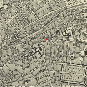
Segment of John Rocque's 1756 Map of Dublin
Dublin Core
Title
Segment of John Rocque's 1756 Map of Dublin
Creator
John Rocque
Date
1756 (original); 1988 (facsimile)
Rights Holder
Special Collections, University of Victoria
Rights
Special Collections, University of Victoria
Subject
Cartography--Ireland--Dublin--History.
Surveying--Ireland--History.
Dublin (Ireland)--Maps.
Dublin (Ireland)--Historical geography--Maps.
Dublin (Ireland)--Geography.
Surveying--Ireland--History.
Dublin (Ireland)--Maps.
Dublin (Ireland)--Historical geography--Maps.
Dublin (Ireland)--Geography.
Description
Segment of a facsimile copy of John Rocque's Plan of the City of Dublin, published in London in 1756. The red dot shows the approximate location of No. 58 Dame-Street, the eventual location of Caleb Jenkin's bookshop.
Source
Special Collections, University of Victoria G1834 D8S1H5 1988
Publisher
National Library of Ireland
Contributor
G. Kirk
Format
Map
Language
English
Type
Image
Date Created
December 1, 2017
Bibliographic Citation
Rocque, John, et al. “Exact Survey of the City and Suburbs of Dublin.” Historic Dublin Maps, National Library of Ireland, 1988, p. 8.
Files
Citation
John Rocque, “Segment of John Rocque's 1756 Map of Dublin,” UVic Libraries Omeka Classic, accessed June 1, 2022, https://omeka.library.uvic.ca/items/show/1359.
Embed
Copy the code below into your web page

